Pigeon Forge Traffic Tips
Bypassing Traffic In Pigeon Forge
During Rod Runs or any highly populated time of the year!
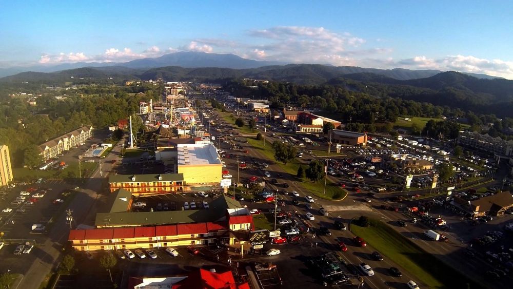
In one of our last posts, we talked at length about the Spring Rod Run and the awesome party it brings with it that's coming up between April 6th to the 8th. Now, as the event draws closer, we'd like to provide some tips for those of you coming to visit in that timeframe or the peak season to help avoid the frustrations of traffic.
The good news is that because of how interconnected the cities are and how the roadway infrastructure works have here in Sevier County, there are LOTS of backroads, shortcuts and such that can save you quite a bit of time and effort with some forethought and creativity. The bad news is that it's not always easy to see where all those backroads are and if they can really help you. In this post, we'll help you get to know some of the best ways to skip around the main downtown area and get where you need to get with the most efficiency.
Let's take a look:
This street is parallel to the main downtown parkway on the southwest side of town and connects Wears Valley Road to just after stoplight #7 where McDonalds and Corky's BBQ is. This road isn't too long and it’s easy to see where you're going. It's mostly straight except for one left turn up the hill to take at the end as you get towards stoplight #7. This street cuts through nearly half the city.
Google Maps Link:
This street begins at the very end of Pigeon Forge before it turns into the Spur that connects Pigeon Forge to Gatlinburg. Conner Heights is a road that goes directly to Wears Valley and showcases more than 20 minutes of gorgeous, relatively undeveloped countryside (although there are some attractions). It is a long drive, but all you need to do is drive straight and it could save upwards of a full hour of traffic if you're trying to get to Wears Valley from Gatlinburg or vice versa. It also connects to Pine Mountain Road which connects to Rena Street as seen above.
Google Maps Link:
As mentioned above, Pine Mountain Road connects from Rena Street near downtown Pigeon Forge to Conner Heights Road where you can bypass traffic to get to Gatlinburg or Wears Valley much easier. This road is a bit long and goes up and down a lot of curvy roads, but all you have to do keep going straight and then decide which way you want to go from there (left for Pigeon Forge at the start of The Spur, right for Wears Valley).
Google Maps Link:
Ridge Road connects from Teaster Lane, a major road parallel to the main parkway on the Northeast side of town, to Collier Drive in Sevierville. Collier Drive is known as "Governor's Crossing" and further extends to Veteran's Boulevard, which connects Sevierville to Pigeon Forge, and to the WalMart Supercenter. This is a reasonably short drive that has some hills and curves, but all you need to do is go straight until you can't go straight anymore. Turn left to go to WalMart and Governor's Crossing and right to go to Veteran's Boulevard.
Google Maps Link:
This road connects from Dollywood Lane, a parallel road on the Northeast side of town between The Old Mill and the Dollywood Ticket Center on the parkway in Pigeon Forge, to Dunn's Mill where you can get to Sevierville or the Arts and Crafts Community of Gatlinburg. This road is somewhat long but filled with beautiful scenery, some arts and crafts stores and no complicated directions whatsoever. Just drive straight until you can't anymore, then go right for Gatlinburg or left for Sevierville.
Google Maps Link:
With these roads as part of your planning, you'll be driving further but still saving potentially hours of traffic time during the Rod Runs or any highly populated time of the year!
During Rod Runs or any highly populated time of the year!
In one of our last posts, we talked at length about the Spring Rod Run and the awesome party it brings with it that's coming up between April 6th to the 8th. Now, as the event draws closer, we'd like to provide some tips for those of you coming to visit in that timeframe or the peak season to help avoid the frustrations of traffic.
The good news is that because of how interconnected the cities are and how the roadway infrastructure works have here in Sevier County, there are LOTS of backroads, shortcuts and such that can save you quite a bit of time and effort with some forethought and creativity. The bad news is that it's not always easy to see where all those backroads are and if they can really help you. In this post, we'll help you get to know some of the best ways to skip around the main downtown area and get where you need to get with the most efficiency.
Let's take a look:
- Rena Street.
This street is parallel to the main downtown parkway on the southwest side of town and connects Wears Valley Road to just after stoplight #7 where McDonalds and Corky's BBQ is. This road isn't too long and it’s easy to see where you're going. It's mostly straight except for one left turn up the hill to take at the end as you get towards stoplight #7. This street cuts through nearly half the city.
Google Maps Link:
- Conner Heights Rd.
This street begins at the very end of Pigeon Forge before it turns into the Spur that connects Pigeon Forge to Gatlinburg. Conner Heights is a road that goes directly to Wears Valley and showcases more than 20 minutes of gorgeous, relatively undeveloped countryside (although there are some attractions). It is a long drive, but all you need to do is drive straight and it could save upwards of a full hour of traffic if you're trying to get to Wears Valley from Gatlinburg or vice versa. It also connects to Pine Mountain Road which connects to Rena Street as seen above.
Google Maps Link:
- Pine Mountain Rd.
As mentioned above, Pine Mountain Road connects from Rena Street near downtown Pigeon Forge to Conner Heights Road where you can bypass traffic to get to Gatlinburg or Wears Valley much easier. This road is a bit long and goes up and down a lot of curvy roads, but all you have to do keep going straight and then decide which way you want to go from there (left for Pigeon Forge at the start of The Spur, right for Wears Valley).
Google Maps Link:
- Ridge Road
Ridge Road connects from Teaster Lane, a major road parallel to the main parkway on the Northeast side of town, to Collier Drive in Sevierville. Collier Drive is known as "Governor's Crossing" and further extends to Veteran's Boulevard, which connects Sevierville to Pigeon Forge, and to the WalMart Supercenter. This is a reasonably short drive that has some hills and curves, but all you need to do is go straight until you can't go straight anymore. Turn left to go to WalMart and Governor's Crossing and right to go to Veteran's Boulevard.
Google Maps Link:
- Upper Middle Creek
This road connects from Dollywood Lane, a parallel road on the Northeast side of town between The Old Mill and the Dollywood Ticket Center on the parkway in Pigeon Forge, to Dunn's Mill where you can get to Sevierville or the Arts and Crafts Community of Gatlinburg. This road is somewhat long but filled with beautiful scenery, some arts and crafts stores and no complicated directions whatsoever. Just drive straight until you can't anymore, then go right for Gatlinburg or left for Sevierville.
Google Maps Link:
With these roads as part of your planning, you'll be driving further but still saving potentially hours of traffic time during the Rod Runs or any highly populated time of the year!