Top 3 Winter Hikes in the Smokies
Our Top 3 suggestions for winter hikes
In this article, we'll showcase the 3 hiking trails we feel will capture this experience in the best ways possible. Let's look!
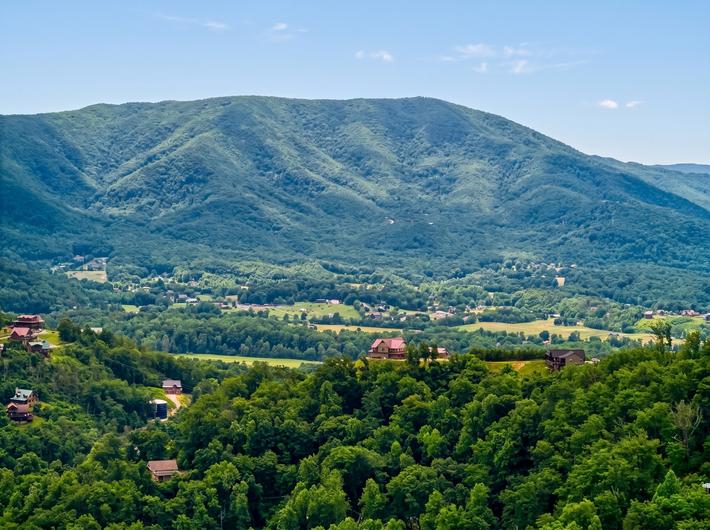
Winterfest in the Smoky Mountains is more than just the Thanksgiving, Christmas and New Years holidays - it's actually functionally a season that goes on for up to 1/3 of the entire year in East Tennessee. In Smoky Mountain parlance, we associate Winter with mid-November as far up as mid-March (sometimes even later). After the parties are done, we still have almost 3 months of solid Winter season.
So, what's there to say about that? Everyone needs a good downtime after a big festive occasion and the Smoky Mountains are no different. For those who want to come to the Smokies to relax and find things to do that enhance a sense of spirituality, introspection, and reflection upon nature, truth and being, the post-holiday Winterfest is THE best time to come! Not only is it much, much quieter with a lot more room to breathe amongst the road traffic and National Park attractions, but it's also the best time to get to see the Smokies covered in snow! January-March is when we get the best chances for the mountain tips, the foothills and valleys to get covered in white - and there are fewer more naturally spiritual experiences in East Tennessee than getting to hike a Great Smoky Mountains trail and see the thick forests, heavy ridges, and distant peaks turn into Winter wonderlands.
Laurel Falls
In the midst of a post-holidays Winterfest, some of the best hiking trails to consider are the ones with shorter lengths and waterfalls for the same reason - ice can form very quickly in the Great Smoky Mountains National Park. Snow covers much of the trail grounds, but ice can still make it potentially slippery on the wet rocks and terrain. Laurel Falls is a short and easy length, about 1.3 miles ending with one of the most famous waterfalls in the Smokies. Laurel Falls the waterfall is a huge, 80-foot waterfall with multiple tiers that become unbelievable to look at if frozen over and covered in snow. Definitely worth the hike!
Directions to Trailhead: From the Sugarlands Visitor Center near Gatlinburg, drive 3.8 miles to the top of Fighting Creek Gap. The main parking lot for Laurel Falls will be on your right, with additional parking across the street. From the Townsend "Y" intersection near Cades Cove, the Laurel Falls is 13.7 miles away."
Schoolhouse Gap
Usually noteworthy during the Spring season for its Spring wildflowers, Schoolhouse Gap is also worthy of pre-Spring hiking considerations as is 1.9 miles in length, has paths wide enough for horses to go through (as it is, in fact, a horseback riding trail as well) and is close enough to Cades Cove that you could expect to see some of the same kinds of wildlife out or nearby. Have you ever seen a bright red cardinal perched against a bright white snow-covered trail? Or a deer crossing your path as the winter weather gently falls around you? It's like a Smoky Mountain painting come to life! There is a stream you come across that freezes over and two other trails that Schoolhouse Gap branches off to - Chestnut Top Trail and another unnamed trail that goes down to the White Oaks Sinks. A very interesting trail with a lot of opportunities for hikers!
"Directions to Trailhead: From the Townsend "Y" junction, drive west on Laurel Creek Road towards Cades Cove. The parking area for the Schoolhouse Gap Trailhead is located on your right, roughly 3- 1/2 miles from the Townsend "Y" junction.
Porters Creek Trail
This trail is a bit longer than Laurel Falls and Schoolhouse Gap at 2 miles in length and has some increased difficulty, but this trail has some advantages in that it has some of the lowest elevations in the Great Smoky Mountains National Park - which means that it normally does not get closed for weather activity. The first mile of it is also gravel terrain which makes the trail wider and easier to traverse under snowfall. There are historic structures you can see on this trail and features a waterfall as well.
Directions to Trailhead: At the junction of 441 and 321 in Gatlinburg (Light 3), turn to travel east on HWY 321. Drive approximately 6 miles and turn right into Greenbrier (look for the Great Smoky Mountain National Park entrance sign on the right). This road turns into a gravel road after a short distance. Use caution as you travel, this road, at points the road is wide enough for one car, you may have to take turns with oncoming traffic. From Route 321 drive 3.1 miles to a fork in the road. Continue straight ahead at this junction to reach the Porters Creek trailhead. The parking area for the trail will be almost another mile from this junction.”
Notes:
This trail offers a variety of exciting elements, approximately two-thirds of a mile from the trailhead several old stone walls will appear on your right. These are remnants from the Elbert Cantrell farmstead, who settled in the Porters Creek community in the early 1900s. Also on your right, just past the stone walls, is the Ownby Cemetery, please use caution and care while inspecting the cemetery which dates back to the early part of the 20th century.
Great photo opportunity for hikers, approximately one mile from the trailhead, after crossing over a footbridge, hikers will reach a fork in the road. The spur trail on the right leads to a historic farm site. A short hike of roughly 250 yards will take you to the John Messer farm site, which includes a cantilevered barn that was built by John Whaley around 1875. There's also a cabin on this site that was built by the Smoky Mountain Hiking Club in the mid-1930s.”